#slovakia
Found 16 results for tag #slovakia
Trails - Trails (14)
- Difficulty: 21.4 km Duration: 10 h 10 min
Banówka (Baníkov)
A climb to the summit of the Western Tatras (on the main ridge). An incredibly scenic but technically demanding peak, requiring a head for heights and the ability to climb with your hands.
Difficulty: difficult (high exposure, climbing, chains!)
#slovakia #western tatras #západné tatry +3View trail - Difficulty: 16.7 km Duration: 8 h 25 min
Baraniec (Baranec)
The third-highest peak in the Western Tatras. A challenging scenic loop above the Żarska Valley, offering a 360-degree panorama and... a scooter ride back down.
Difficulty: difficult (very steep gradient!)
#slovakia #western tatras #condition +2View trail - Difficulty: 28 km Duration: 11 h 48 min
Bystra (Bystrá)
A hike to the highest peak in the entire Western Tatras (2,248 m above sea level). A physically demanding route leading through the picturesque Ornak Ridge and the border peak of Błyszcz.
Difficulty: very demanding (physically)
#slovakia #western tatras #highest peak +2View trail - Difficulty: 13 km Duration: 8 - 10 h
Gerlach (Gerlachovský štít)
Gerlach is the highest peak of the Tatras and the entire Carpathians. It is the "Holy Grail" for Tatra enthusiasts. Because there is no marked tourist trail leading to it, the mountain has retained its raw high-mountain character.
Difficulty: climbing route (UIAA I/II) - very difficult
#slovakia #high tatras #highest peak +2View trail - Difficulty: 20.6 km Duration: 10 h 23 min
Jagnięcy Szczyt (Jahňací štít)
A trip to the eastern edge of the High Tatras. The trail leads through the scenic Kežmarok Valley, past the emerald Zelené Pleso, all the way to a viewpoint summit opposite the Bielskie Tatras.
Difficulty: difficult (very long + chain section)
#slovakia #high tatras #chains +2View trail - Difficulty: 20.9 km Duration: 8 h 37 min
Koprowy Wierch (Kôprovský štít)
A quiet alternative to Rysy. A striking summit with a view of the largest lake in the Slovak Tatras - Wielki Hińczowy Staw.
Difficulty: difficult (fitness + exposure)
#slovakia #high tatras #lake +2View trail - Difficulty: 19.8 km Duration: 8 h 55 min
Krywań (Kriváň) - The national mountain of Slovakia
Krywań is a symbolic mountain. Its characteristic curved summit is recognisable from hundreds of kilometres away. For Slovaks, climbing Krywań is a patriotic duty - every August mass "National Ascents" (Národný výstup) take place here.
Difficulty: difficult (fitness-wise!)
#slovakia #high tatras #symbol +2View trail - Difficulty: 0 km Duration: 3 h (cable-car trip in total)
Lomnica (Lomnický štít)
Lomnica is the proud "Queen of the Tatras". Its silhouette is so sharp that for centuries it was believed to be the highest peak in the Tatras (only precise measurements dethroned it in favour of Gerlach).
Difficulty: very easy (cable car) / climbing route (on foot with a guide)
#slovakia #high tatras #cable car +2View trail - Difficulty: 7.4 km Duration: 4 h 45 min
Mała Wysoka (Východná Vysoká)
Mała Wysoka is a summit with a misleading name. It is not "small" at all - it is the fourth highest summit in the Tatras accessible by a marked tourist trail!
Difficulty: difficult (exposure + fitness)
#slovakia #high tatras #panorama +2View trail - Difficulty: 20 km Duration: 8 h 30 min
Rysy (from the Slovak side)
The ascent to Rysy from the Slovak side is the most popular and easiest route to the highest peak of the Tatras. Unlike the dark and precipitous north wall (the Polish side), the Slovak trail follows a sunny southern slope.
Difficulty: difficult (fitness-wise)
#slovakia #high tatras #highest peak +2View trail - Difficulty: 8.8 km (round trip from Wyżnia Huciańska Pass) Duration: 5 h 50 min
Siwy Wierch (Sivý vrch)
The Dolomite Tatras! A hike to a limestone summit full of rock cities (Radové skaly). An exciting trail secured with chains at the very edge of the Western Tatras.
Difficulty: medium / difficult (chains, exposure)
#western tatras #slovakia #rock city +2View trail - Difficulty: 10 km (on foot) / 2 km (from the upper cable car station) Duration: 4 h 27 min (on foot) / 1 h 30 min (with the cable car)
Skrajne Solisko (Predné Solisko)
One of the most accessible 2,000-metre peaks in the Tatras. A cable car can take you almost to the summit, and a short but rewarding climb offers views of Štrbské Pleso.
Difficulty: medium (steep summit approach)
#slovakia #high tatras #cable car +2View trail - Difficulty: 12.5 km Duration: 7 h 27 min
Sławkowski Szczyt (Slavkovský štít)
Sławkowski Szczyt (2452 m a.s.l.) is a massive, broad massif dominating Stary Smokovec. It is one of the highest peaks in the Tatras that can be reached by a marked tourist trail without chains or rungs.
Difficulty: difficult (fitness-wise), easy (technically)
#slovakia #high tatras #fitness +1View trail - Difficulty: 21.5 km Duration: 8 h 41 min
Wielka Świstówka (Veľká Svišťovka)
A spectacular traverse between two of the most famous valleys. The trail links Zeleny Staw with Skalnaté Pleso, offering an exciting chain-assisted section and a bird’s-eye view of the Kežmarok Valley.
Difficulty: medium / difficult (chain section)
#slovakia #high tatras #lake +2View trail
Blog - Blog (2)
 2026-06-28
Want the High Tatras but scared of chains? The easiest rocky summits
Do you dream of “real”, sharp, rocky mountains, but the thought of exposure and chains makes your legs shake? Here’s a list of summits you’ll reach like climbing stairs — without climbing gear.
#easy routes #tips #high tatras +2View post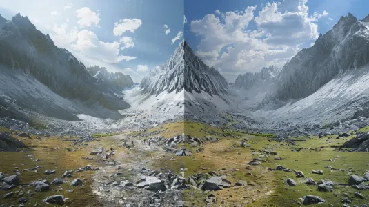 2026-02-22
Poland vs Slovakia: Where to go in the Tatras? A big clash between neighbours
Crowds on Giewont or empty slopes (and high prices) in Slovakia? Kwaśnica or Vyprážaný syr? We’re finding out which side of the Tatras to choose so you won’t regret your holiday.
#poland #slovakia #comparison +2View post
Did you find the information here useful? I spent quite a bit of time compiling it. If it helped you plan your trip, buy me a virtual coffee! ☕
Buy me a