The recommended route is on this page. A different start has its own page — description and map.
Approach variants
Variant
Start
Duration
Chains
Trail color
Waterfall – tarns – ŤatliakovaRecommended
Asphalt to Adamcuľa, blue to the waterfall and tarns, green to Ťatliakova, red down. No chains. The tiles show this loop.
Pod Spálenou
5 h 50 min
No
red
blue
green
Ťatliakova chata only
Asphalt up Roháčska dolina and back. No tarns, no closure of the upper loop. Still not a pushchair.
Pod Spálenou
2 h 40 min
No
red
Start at Chata Zverovka
The official Zuberec loop. Shorter by the walk from the car park. The same tarns, the same closure.
Chata Zverovka
5 h 45 min
No
red
blue
green
Recommended
Waterfall – tarns – Ťatliakova
Asphalt to Adamcuľa, blue to the waterfall and tarns, green to Ťatliakova, red down. No chains. The tiles show this loop.
The longer description below is about the recommended variant.
🗺️
Map and trail profile
Waterfall – tarns – Ťatliakova
🚗
Getting there, parking & buses
Trailhead logistics – reach the start smoothly without parking hassle.
📍Trailhead:Pod Spálenou car park (Roháče)
🅿️
Parking & car access
💶Paid in Euros (large ski resort parking)
Pod Spálenou (Roháče–Spálená resort)
Parking fee: paid (about €5–10 / day)
💡Very large paved parking lot at the entrance of Roháčska Valley. Base for Roháče Lakes, Baníkov, and the crest. Slovak mountain insurance is mandatory!
Roháčske plesá (highest tarn 1,719 m a.s.l.) is the clearest viewpoint loop in the Slovak Western Tatras. Four lakes under the Roháče, an 18 m waterfall, and an asphalt road that is a ski run in winter and an approach in summer.
💡 In a nutshell – Roháčske plesá:
For whom: People with half-day fitness. No chains, a lot of stone.
Direction: Blue to the waterfall, green past the tarns, red down. Fewer jams at the fall.
Golden rule:1 November – 15 June closed. The lower asphalt to Ťatliakova may stay open — the tarns do not.
Dog: Prohibited on the tarn loop (TANAP regulations). Leashed dogs allowed only up the asphalt to Ťatliakova chata. HZS is billed.
The tiles count the loop from the Pod Spálenou car park, not the shortcut from Zverovka’s door.
Trail description: Waterfall first
Stage 1: Adamcuľa
From the car park red asphalt up Roháčska dolina to Adamcuľa. Here you turn blue into Spálená instead of walking straight to Ťatliakova.
Stage 2: Roháčsky vodopád
Forest, stones, after about 40 min the waterfall step. Wet after rain. Blue then leaves the trees for the cirques under Predný Zelený.
Stage 3: Four tarns
Green climbs steeply to the fourth Roháčske pleso (1,719 m), then down past the third, second and first. This is why you came.
Stage 4: Ťatliakova and asphalt
A snack bar by Ťatliakovo pleso. Red asphalt back to the car park. The knees will notice those last kilometres.
Logistics and warnings
Access: Zuberec → Roháče–Spálená. Paid parking. A bus to Zverovka if you do not want a car.
Closure: 1 Nov–15 June on the tarn loop. Check TANAP before you drive.
Insurance: Horská služba is billed.
Dog: Banned on trails above the waterfall and on the tarn loop (TANAP regulations).
The Roháče peaks: Ostrý Roháč and Plačlivé are a separate chained ridge, not this card.
Who is this absolutely NOT for?
Not a pushchair. Not “an hour before lunch”. If you want chains and a ridge, take Baníkov or Sivý vrch. If you want only a lake without 700 m of ascent — stay with Ťatliakova in the table.
No. Stones, zigzags, a waterfall. This is not Baníkov and not Sivý vrch.
When is the loop closed?
From 1 November to 15 June. TANAP closes trails above the huts and this path around the tarns.
Which way: waterfall first or Ťatliakova first?
The tiles go up past the waterfall and down past the tarns to Ťatliakova. The other way you hit the jam at the waterfall on the descent.
Can I bring a dog?
Not to the tarns. TANAP regulations strictly ban dogs above Roháčsky vodopád and on the entire loop around the Roháčske tarns (marmot and chamois protection). You may only walk a leashed dog along the lower asphalt road to Ťatliakova chata.
🗺️
Next trail in this area
Planning your next hike? From the same starting point and area, we recommend:
Baraniec from the Žiarska Valley car park: yellow onto the ridge, the summit, green down to the hut. The tiles are the loop, 16.7 km / 8 h 25 min. No chains. The trail above the hut is closed 1 Nov–15 Jun.


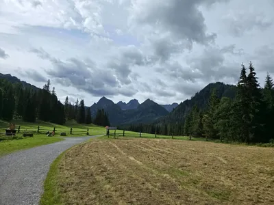 Distance: 24.7 kmDuration: 7 h 38 min
 2026-10-05
 2026-10-02
 2026-09-27
 2026-10-08
 2026-10-07
 2026-10-06
 2026-10-04
 2026-10-04
 2026-10-03